Home › Antique Maps of Ancient Greece › Ancient Greece
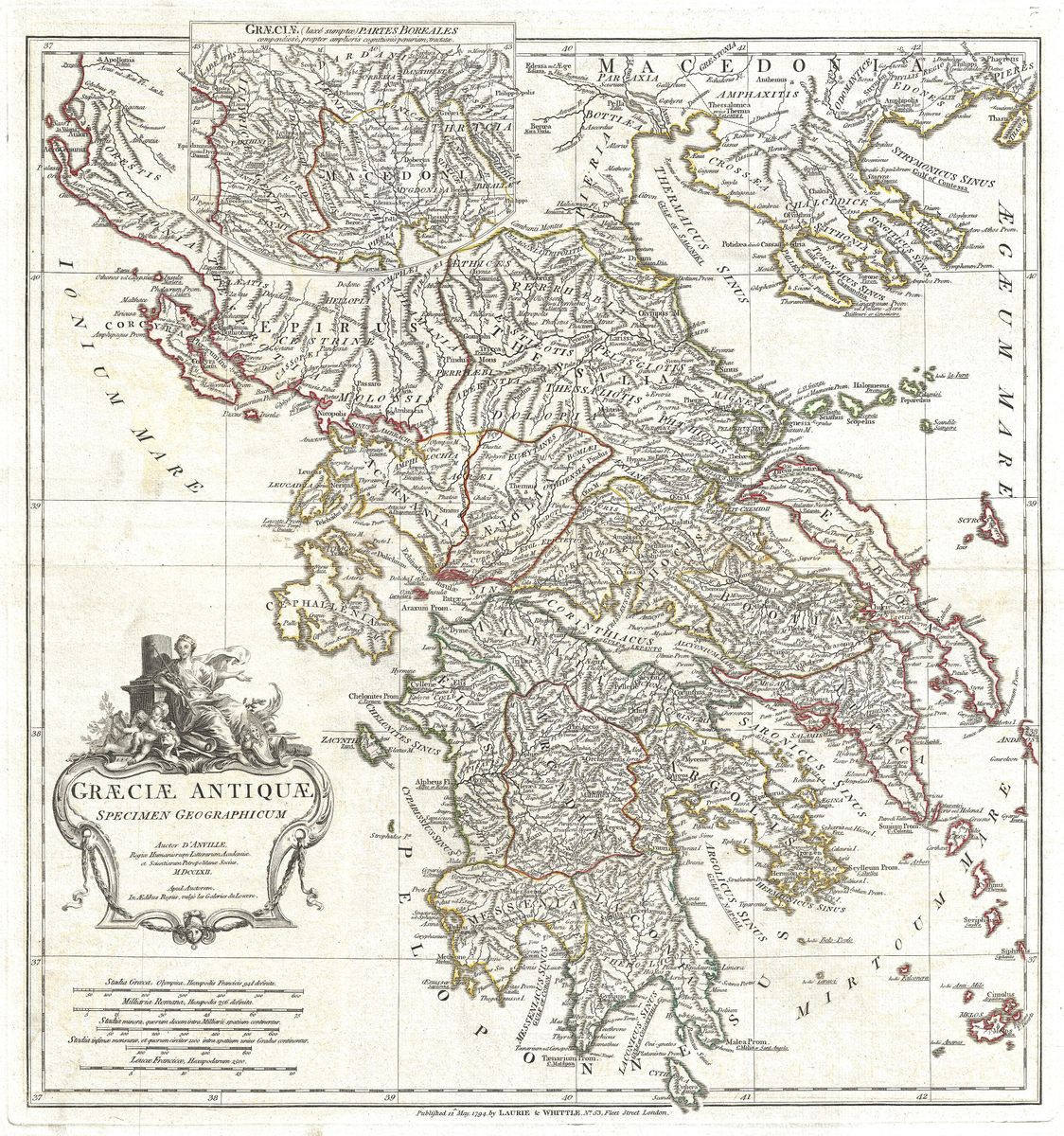
Ancient Greece — Antique Map (1794)
Jean-Baptiste Bourguignon d'Anville, 1794 — Greek world
This 1794 map depicts ancient Greece as the classical sources described it, the Hellenic heartland set between the Ionian and Aegean seas. The mainland regions are laid out in careful order, from Macedonia and Thessaly in the north, through Epirus, Boeotia and Attica, down to the Peloponnese with its districts of Laconia, Messenia and Arcadia. The islands of the Aegean, the Cyclades and the long coastlines that shaped Greek seafaring are recorded with their ancient names, giving a clear picture of the geography in which the city-states rose and contended.
Jean-Baptiste d'Anville and classical geography
Jean-Baptiste Bourguignon d'Anville (1697-1782) was the foremost cartographer of the classical world in the eighteenth century. His distinction lay in method: where earlier mapmakers had filled their sheets with conjecture and inherited error, d'Anville worked from ancient texts, itineraries and sound reasoning, and was willing to leave blank what the sources could not support. The result was a body of classical maps prized for their restraint and accuracy, which served as standard references for generations of scholars. This rendering of Greece, issued in the years after his death from his carefully prepared plates, carries that same scholarly authority.
The world of the city-states
The Greece shown here is the fragmented yet brilliant world of the polis, in which independent cities such as Athens, Sparta, Corinth and Thebes pursued their own politics, rivalries and alliances. It was a landscape that shaped its history: mountains divided communities, the sea connected them, and scarce arable land drove colonisation across the Mediterranean. From this setting came the achievements that still define the classical inheritance, in philosophy, drama, sculpture, athletics and the early experiments in citizen government. A map of the region is therefore also a map of the ideas that grew within it.
For the collector and the home
Restored in high resolution from a public-domain original, the map preserves the clarity and quiet elegance of d'Anville's engraving while presenting it for comfortable modern viewing. For lovers of Greek history, mythology or the classics, it is an evocative and genuinely authentic wall piece, equally at home in a study, a library or a quiet reading corner. It is offered as an archival giclée print, framed and ready to hang.