Home › Antique Maps of Ancient Greece › Greece and Asia Minor
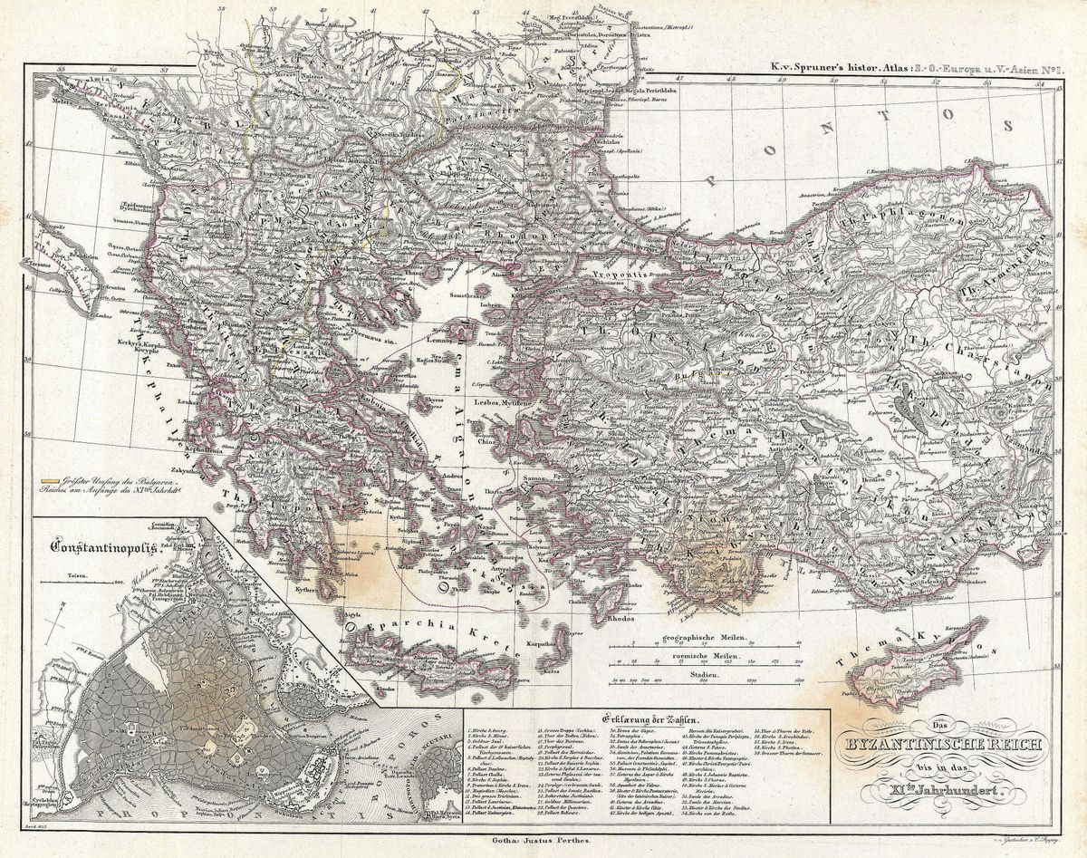
Greece and Asia Minor — Antique Map (1854)
Karl von Spruner, 1854 — Greek world
This 1854 map sets out Greece and Asia Minor together, the two facing shores of the Aegean that formed the heart of the classical Greek world. To the west lie the mainland regions and islands of Greece; to the east, the Anatolian coast with Ionia, Aeolis and the long line of Greek settlement that fringed the peninsula. Regions, colonies and historic boundaries are marked with the careful annotation typical of a scholarly historical atlas, so that the map reads less as decoration than as an argument about how the ancient landscape was organised.
Karl von Spruner and historical cartography
Karl von Spruner (1803-1892) was the great German master of historical cartography, and his atlases mapped the past with a rigour that set the standard for the discipline. Rather than charting the present, Spruner reconstructed earlier worlds, fitting political boundaries, peoples and place-names to particular periods of history. His work was central to the nineteenth-century German tradition of historical scholarship, which treated geography as an indispensable tool for understanding the events of antiquity. A map such as this was intended for students and scholars who needed to see precisely where the Greek world met the older civilisations of the East.
The shores of the Aegean
The lands shown here were bound together by the sea between them. The cities of the Ionian coast, among them Miletus and Ephesus, were as much a part of the Greek world as Athens or Corinth, and it was on this eastern shore that Greek philosophy and natural inquiry first flourished. Asia Minor was also a meeting ground of cultures, where Greek settlement overlapped with older Anatolian peoples and, in time, with Persian and then Roman power. The map captures a world in which the Aegean was not a barrier but a thoroughfare, joining colonies, trade routes and rival powers across its waters.
For the collector and the home
Restored in high resolution from a public-domain original, this map preserves the precise, academic character of Spruner's engraving while presenting it cleanly for display. It is a thoughtful choice for students of antiquity and the Hellenic world, or for anyone who appreciates the disciplined beauty of a German historical atlas. It is offered as an archival giclée print, framed and ready to hang.