Home › Antique Maps of Ancient Greece › Asia Minor
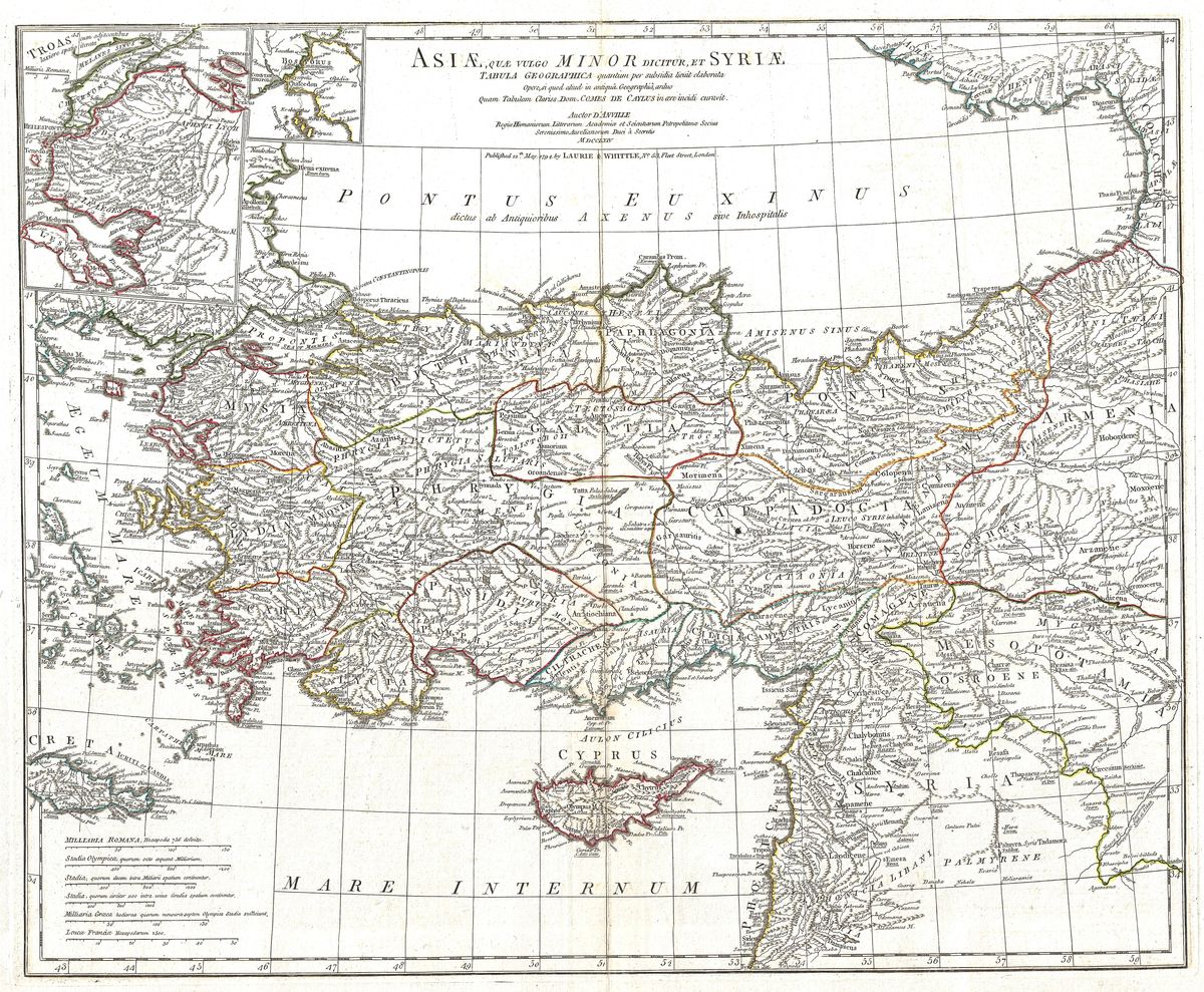
Asia Minor — Antique Map (1794)
Jean-Baptiste Bourguignon d'Anville, 1794 — Greek world
This 1794 map details Asia Minor, the great peninsula of ancient Anatolia that today forms much of Turkey. Its classical regions are set out across the sheet, among them Ionia and Lydia along the Aegean shore, Phrygia and Galatia in the interior, Cappadocia to the east, and Bithynia and Pontus on the Black Sea coast. The map records the seats of the old Greek cities of the eastern Aegean and the deeper Anatolian lands behind them, capturing a peninsula that served as a bridge between the Mediterranean and the Near East.
Jean-Baptiste d'Anville and his method
Jean-Baptiste Bourguignon d'Anville (1697-1782) reshaped the mapping of the ancient world by insisting on evidence over invention. Drawing on classical authors, ancient itineraries and a critical comparison of sources, he produced maps that were notable for their accuracy and their honest acknowledgement of uncertainty. This care made his classical geography the reference of his age and well beyond it. His treatment of Asia Minor reflects that discipline, organising a complex patchwork of regions and peoples into a clear and reasoned whole, free of the decorative excess that cluttered many earlier maps.
A crossroads of antiquity
Few regions carried more history than Asia Minor. Its western coast hosted Troy and the Ionian cities where Greek civilisation took some of its earliest intellectual steps, while its interior was home to ancient kingdoms such as Lydia, whose ruler Croesus became a byword for wealth. The peninsula passed in turn under Persian, Hellenistic and Roman control, and its roads and ports linked the Aegean world to Mesopotamia and the East. To map Anatolia is to map a meeting place of Greek, Persian and Roman fortunes, where empires expanded, clashed and left their mark.
For the collector and the home
Restored in high resolution from a public-domain original, the map preserves the measured clarity of d'Anville's engraving while presenting it cleanly for display. It makes an excellent choice for collectors of Hellenistic and Roman history, or for anyone with a particular attachment to the lands of ancient Anatolia. It is offered as an archival giclée print, framed and ready to hang.