Home › Antique Maps of Ancient Greece › Greece and Epirus
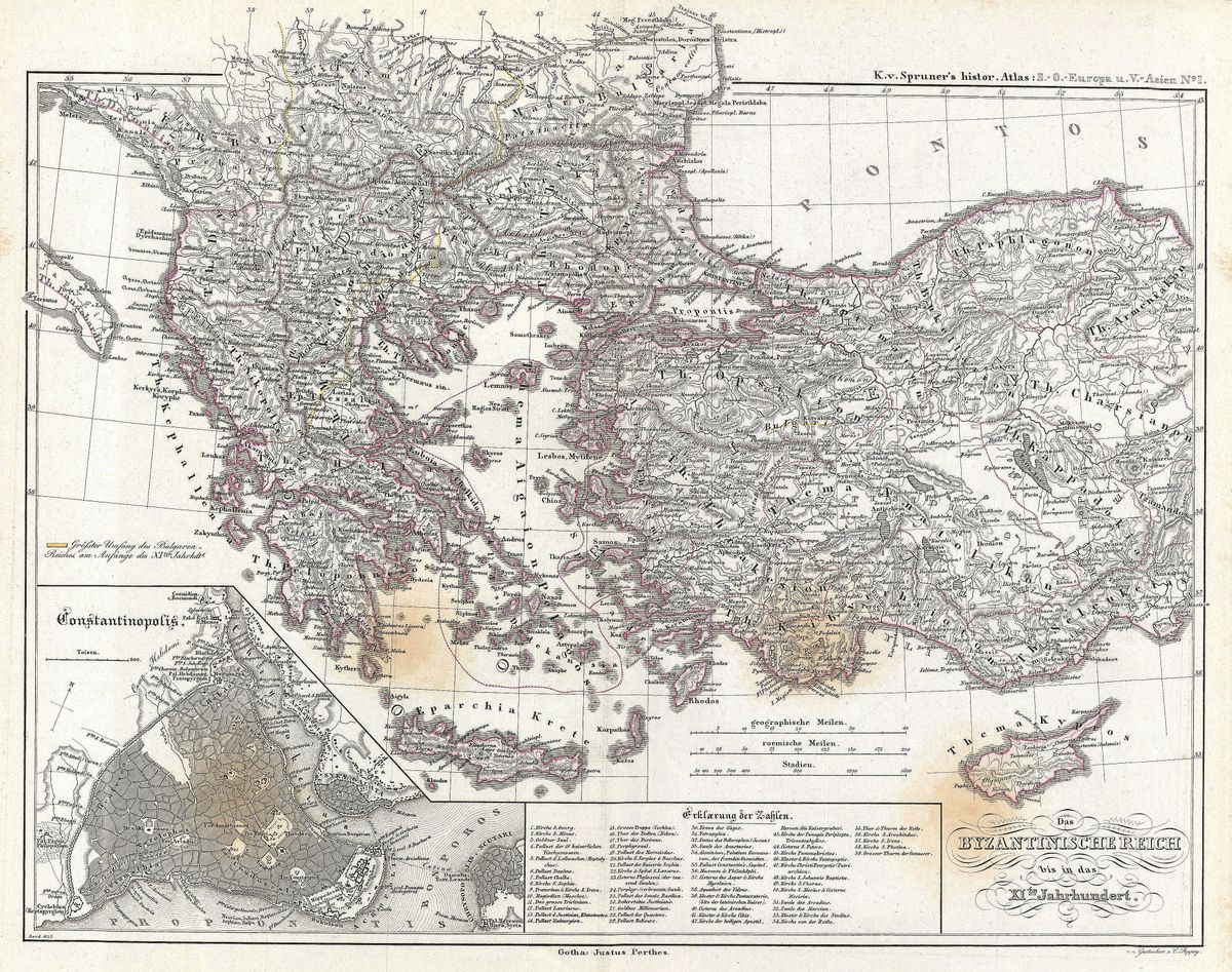
Greece and Epirus — Antique Map (1865)
Karl von Spruner, 1865 — Greek world
This 1865 map concentrates on Greece and Epirus, the mountainous north-western quarter of the Hellenic world and the lands that adjoin it. Epirus occupies the rugged country between the Pindus range and the Adriatic, with Greece proper extending southward and eastward from it. Regions, peoples and ancient sites are carefully placed, allowing the viewer to follow the difficult terrain of valleys, mountains and coast that defined how this part of the Greek world was settled and fought over.
Karl von Spruner and the historical atlas
Karl von Spruner (1803-1892) brought to historical cartography an unusual command of both geography and the written record. His atlases were prized for fitting the ancient landscape to the events that unfolded upon it, so that frontiers, campaigns and territories could be read directly from the sheet. Working within the strong German scholarly tradition of the nineteenth century, he produced maps intended to accompany serious historical study rather than to decorate a wall. The 1865 dating places this map among the mature products of that tradition, refined over decades of revision and reissue.
Epirus and the western Greek frontier
Epirus was a borderland in every sense, the gateway between the Greek world and the Adriatic, and a region whose rulers periodically reached for a larger stage. Its most famous figure, King Pyrrhus, carried his armies into Italy in the early third century BC and gave his name to the costly Pyrrhic victory. The region's mountains long kept it apart from the city-state culture of the Aegean coast, lending it a distinct character among the Greek lands. By focusing on this often-overlooked corner of Hellas, the map illuminates a frontier where Greek, Macedonian and later Roman interests met and collided.
For the collector and the home
Restored in high resolution from a public-domain original, the map keeps the fine detail and scholarly clarity of Spruner's work while presenting it for modern display. As a subject, Greece and Epirus make an unusual and genuinely considered choice for lovers of Greek history, away from the more familiar views of Athens and the Peloponnese. It is offered as an archival giclée print, framed and ready to hang.