Home › Antique Holy Land Maps › Israel and Palestine
Israel and Palestine — Antique Map (1794)
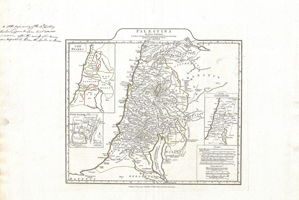
Jean-Baptiste Bourguignon d'Anville, 1794 — Holy Land
This 1794 map of Israel and Palestine by Jean-Baptiste Bourguignon d'Anville approaches the Holy Land with the cool exactitude that made its author the most respected geographer of the Enlightenment. Where earlier mapmakers crowded their charts of the region with ships, figures and scriptural vignettes, d'Anville pares the image back to its geography: the coastline and the Jordan valley, the hill country of Judaea and Samaria, the Dead Sea and the desert margins, each set down with measured care. Ancient and biblical names are placed according to the best textual and classical evidence available, producing a map that reads as much like a work of scholarship as a devotional object.
D'Anville, geographer of the ancient world
Jean-Baptiste Bourguignon d'Anville (1697-1782) reformed the mapping of antiquity. Rather than copying the embellishments of his predecessors, he weighed the testimony of ancient authors, itineraries and inscriptions, and was famously willing to leave blank what could not be reliably known. His maps of the classical and biblical lands became the standard references of their age and were reissued for decades after his death; this 1794 edition is one such posthumous printing, carrying his authority into the next generation. The restraint of his style, clear line-work, sparing ornament, disciplined lettering, gives his maps a timeless, almost modern clarity.
The land between empires
The territory depicted here had been a meeting point of civilisations since antiquity: the homeland of ancient Israel and Judah, later a province under Roman and Byzantine rule, and the setting of the events recorded in both Testaments. D'Anville's purpose was to recover the historical geography of this land, to locate the cities, tribes and routes named in ancient sources within an accurate framework. The result situates Jerusalem, the coastal cities and the inland towns in their proper relation, offering a sober, scholarly portrait of a region that most contemporaries encountered through faith rather than survey.
Collecting and display
Restored in high resolution from a public-domain original, this print retains the fineness of d'Anville's engraving and the soft patina of antique paper. Its clarity and lack of clutter make it an unusually versatile piece, at home in a study, library or quiet interior where good cartography is appreciated for its own sake. Offered as an archival giclée print, framed and ready to hang, it will appeal to collectors who prize scholarship as highly as decoration.