Home › Antique Maps of the Ancient World › Constantinople
Constantinople — Antique Map (1638)
Matthäus Merian, 1638 — Byzantine Empire
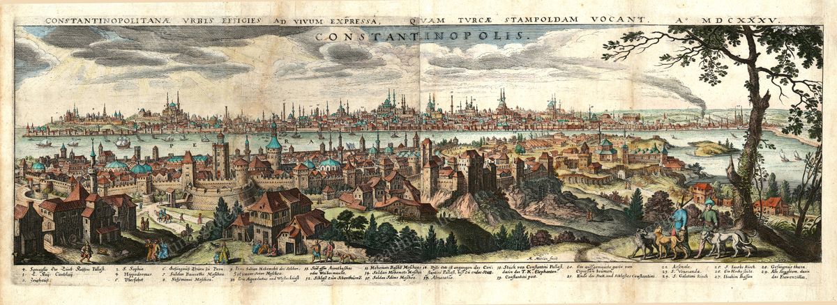
This is a panoramic profile view of Constantinople — a wide prospect of the city's skyline seen from across the water, in the seventeenth-century tradition of the city view rather than a flat plan. Domes, minarets and the sprawl of the great city rise above the harbour, ships work the straits, and a numbered key along the foot of the sheet identifies the principal monuments. Its Latin title notes the city quam Turcae Stampoldam vocant — «which the Turks call Stampolda» — an early European rendering of the name that would become Istanbul.
Matthäus Merian and the city view
Matthäus Merian (1593–1650) was a Swiss-born engraver who settled in Frankfurt and became one of the most influential publishers of his century. Through vast illustrated series such as the Topographia, his workshop shaped how Europeans pictured the cities of their world. This prospect, with its plate dated 1635 (MDCXXXV), is a fine example of that art, balancing topographical information against the drama of the composition.
The city on the Bosphorus
The Constantinople shown here was the capital of the Ottoman Empire, yet it remained the direct heir of Byzantium — the city of Constantine, capital of the Eastern Roman Empire for over a thousand years until 1453. The great church of Hagia Sophia, by then a mosque, stands among the landmarks crowning the skyline. Straddling Europe and Asia, the city was among the largest and most cosmopolitan in the world.
Collecting and display
Restored in high resolution from a public-domain original, this dramatic horizontal piece is offered as an archival giclée print, framed and ready to hang — a compelling choice for lovers of Istanbul, Byzantium and the golden age of topographical engraving.
Browse all Antique Maps of the Ancient World →
Catalogue & provenance
- Title
- Constantinopolitanae Urbis Effigies ad Vivum Expressa, quam Turcae Stampoldam Vocant. A° MDCXXXV
- Source
- Matthäus Merian topographical works (Frankfurt)
- Edition / state
- Engraved by Matthäus Merian the Elder (1593–1650); the plate carries the engraved date MDCXXXV (1635), reissued in Merian's topographical series c.1638. A bilingual Latin/German key of 27 landmarks runs along the lower margin.
- Catalogue reference
- Wüthrich, Das druckgraphische Werk von Matthaeus Merian d. Ä., vol. 4
- Held by
- Historisches Museum Frankfurt; Germanisches Nationalmuseum, Nuremberg.
Public-domain original; this is a restored, watermarked reproduction. We never distribute the high-resolution master. Catalogue data compiled from the institutions above.
Featured in the Journal
‘Stampolda’: a 1635 panorama catches a city changing its name →
Matthäus Merian's sweeping view of Constantinople records the name on its way to Istanbul.