Home › Antique Maps of the Ancient World › Arabia and Egypt
Arabia and Egypt — Antique Map (1730)
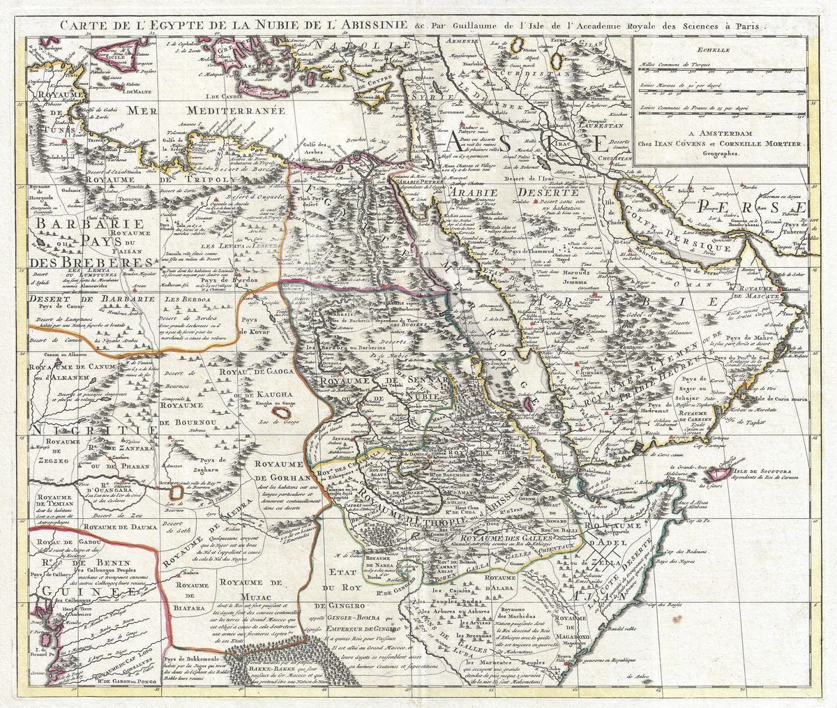
Covens & Mortier, 1730 — Ancient Egypt
This map gathers Arabia and Egypt into a single sweeping view: the Nile threading north through its valley to the Mediterranean delta, the long forked basin of the Red Sea, and the vast Arabian peninsula reaching towards the Persian Gulf and the Indian Ocean. Drawn in the closing decades of the great age of Dutch mapmaking, it names provinces, deserts, ports and ancient regions in the Latin and French forms of the period, and carries the decorative confidence, bold lettering, engraved relief, the occasional cartouche, that distinguished baroque cartography from the plainer maps that followed.
The house of Covens & Mortier
Covens & Mortier was among the most productive map-publishing houses of eighteenth-century Amsterdam. Founded when Johannes Covens joined the established Mortier firm, it built its reputation not on wholly original survey but on acquiring, reissuing and refining the great French and Dutch plates of the previous generation, the work of Sanson, De L'Isle and others, keeping the finest cartography of the age in print and circulation. That role makes their maps a useful index of what educated Europe knew, and chose to show, about the wider world. This 1730 sheet reflects both the strengths and the limits of that knowledge: a well-charted coastline and Nile valley set against an interior still largely sketched from classical authority and traveller's report.
Egypt, Arabia and the ancient Near East
The lands shown here were among the oldest and most storied in the European imagination. Egypt was the country of the pharaohs and the granary of antiquity, its monuments already thousands of years old; Arabia was the land of frankincense and ancient caravan routes, and by 1730 the heartland of Islam, home to Mecca and Medina. The Red Sea between them had carried trade between the Mediterranean and the Indies since antiquity. A European map of this region in the early eighteenth century is therefore a document of fascination as much as fact, a meeting point of biblical geography, classical learning and the commerce that drew Europe eastward.
Collecting and display
As a wall piece it is richly evocative, equally at home with an interest in ancient Egypt, the Near East or the history of cartography itself. It is restored in high resolution from a public-domain original, the warm tone and engraved texture of the period kept intact, and produced as an archival giclée print, framed and ready to hang.