Home › Antique World & Regional Maps › North America
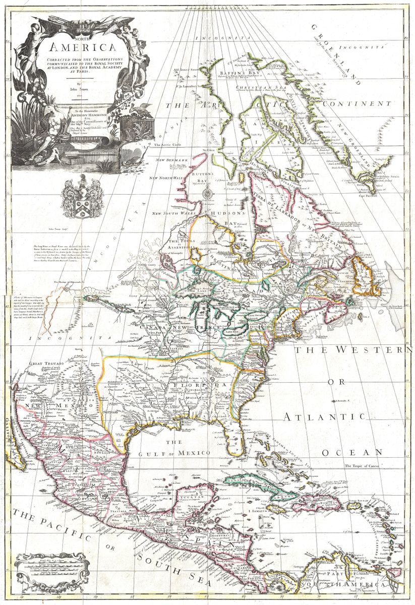
North America — Antique Map (1710)
John Senex, 1710 — North America
John Senex (1678–1740), an English cartographer and Fellow of the Royal Society, published this map of North America in 1710, drawing heavily on the work of the great French geographer Guillaume Delisle. Its grand title declares it 'corrected from the observations communicated to the Royal Society at London and the Royal Academy of Sciences at Paris' — and yet it is gloriously full of myth.
A river that never existed
Cutting westward across the plains runs Baron de Lahontan's 'Long River' (Rivière Longue), a waterway he described in his 1703 travels and now regarded as pure fabrication; the map itself hedges, noting parts were 'drawn by the Savages on deerskins'. Nearby sit Quivira and Teguayo — Coronado's legendary Cities of Gold — set down as if they were real towns.
A continent in contest
One of the earliest large English maps of North America, it captures the intensifying colonial rivalry of Britain, France and Spain, its ornate cartouche personifying 'America' as a feathered queen amid New-World plants and animals.
Collecting and display
Restored in high resolution from a public-domain original and offered as an archival giclée print, framed and ready to hang — a favourite for lovers of cartographic myth and early Americana.
Browse all Antique World & Regional Maps →
Catalogue & provenance
- Title
- North America Corrected from the Observations Communicated to the Royal Society at London and the Royal Academy of Sciences at Paris
- Source
- Senex's Universal Geographer
- Edition / state
- Engraved by John Senex, London, 1710; based heavily on Guillaume Delisle. California correctly shown as a peninsula; the fictional 'Long River' of Baron de Lahontan runs west.
- Catalogue reference
- Stevens & Tree, Comparative Cartography, no. 61a
- Held by
- Washington State University Libraries (MASC); Texas General Land Office, Holcomb Map Collection.
Public-domain original; this is a restored, watermarked reproduction. We never distribute the high-resolution master. Catalogue data compiled from the institutions above.
Featured in the Journal
The 'Long River' a French baron simply made up →
A 1710 map of North America, advertised as 'corrected by the Royal Society', maps a major river that was pure invention.