Home › Antique World & Regional Maps › Paris
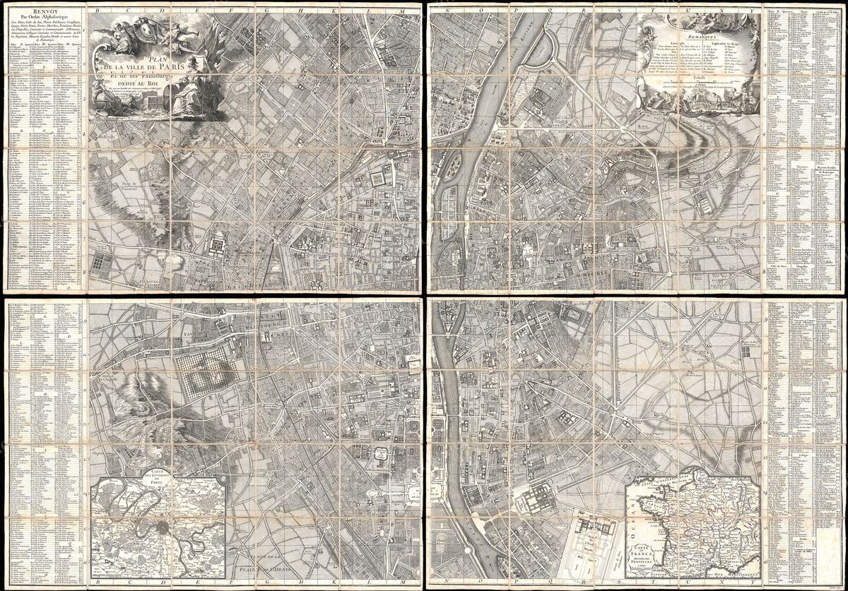
Paris — Antique Map (1767)
Alexis-Hubert Jaillot, 1767 — France
This is a plan of Paris as it stood in the eighteenth century, the city drawn quarter by quarter, its streets, bridges, churches and public squares set down in the close engraved detail that such a survey demanded. The Seine divides the composition as it divides the city, the Île de la Cité at its heart, with the expanding faubourgs spreading outward from the medieval core. Read closely, it is a portrait of the capital on the eve of the Enlightenment's height: a dense, walkable city of parishes and markets, not yet remade by the boulevards of the nineteenth century.
Jaillot and the royal map trade
The plan carries the name of Alexis-Hubert Jaillot (c.1632-1712), who rose from a background in sculpture to become one of the grandest map publishers of the French Grand Siècle and a géographe to Louis XIV. Working closely with the heirs of Nicolas Sanson, Jaillot specialised in large, imposing sheets that matched French cartography to the prestige of the crown. His plates and his name long outlived him, reissued and updated through the eighteenth century, so a 1767 impression speaks to the durability of his house and the enduring appetite for a fine view of the capital decades after his death.
Paris before the modern city
The Paris recorded here was the largest city of continental Europe and the cultural capital of the age, the Paris of the salons, the academies and the philosophes, of a monarchy still secure at Versailles. The street pattern is essentially the medieval and early-modern one: tightly woven, organised around churches and guild quarters, bounded by walls and customs barriers that successive expansions had pushed outward. It is the city before Haussmann's nineteenth-century demolitions, which makes such a plan a precious record of streets and neighbourhoods that have since vanished or been transformed beyond recognition.
Collecting and display
For anyone with an attachment to Paris, by birth, by memory or by affection, a period plan of this kind is among the most resonant of map subjects, rewarding long and repeated looking as one traces familiar names through their older forms. It is restored in high resolution from a public-domain original, the fine engraved line and aged tone preserved, and offered as an archival giclée print, framed and ready to hang.